
Steamboat Engravings - Page 2
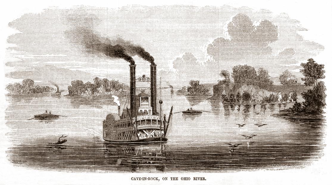
Engraving on page 380 from an issue of Ballou's Pictorial Drawing-Room Companion published sometime between 1854 and 1859. Text scan of the accompanying article on the same page is included below. We have a modern painting by Michael Blaser of Cave-in-Rock among our illustration pages. On one dark night during our voyage from Memphis to Cincinnati in September, 1992 the DELTA QUEEN's Captain or Pilot pulled over slowly and lingered near the Illinois shore where he scanned the mouth of the cave with his searchlight so passengers and members of the crew could enjoy seeing this mysterious grotto on the Ohio River under atmospheric conditions.
"CAVE-IN-ROCK, ON THE OHIO
Cave-in-Rock, or the 'House of Nature,' an accurate view of which, drawn and engraved for the Pictorial, we present on this page, is situated on the Illinois shore of the Ohio River, twenty-four miles below Shawneetown.
It is pointed out to passengers as a great curiosity, and the approach to it, as you descend the stream, is strikingly picturesque.
Above and below it are lofty perpendicular limestone bluffs, surrounded by trees. The entrance to the cave is just above high water mark. It is about 20 feet high, and leads to a spacious apartment with an arched roof, about 30 feet in height, and extending inward to a depth of 125 feet.
On its front are carved the names of many visitor's. This cave has occasionally afforded a temporary winter asylum to families descending the river.
About the year 1800 it was the rendezvous of a noted outlaw and pirate, by the name of Mason, who; with his band, subsisted by plundering flatboats on their way down the river, or by waylaying the unfortunate boatmen on their return, and robbing and murdering them. The voyage down the Ohio was then performed in "arks," which, moving slowly with the current, occupied weeks in the distance that now requires but days.
There was little to relieve the monotony of this dull progress; while the slow pace at which the ark moved, ensured their easy capture by the canoes of Indians or robbers.
Mason availed himself of this, and became the terror of the boatmen. The leader of this notorious band of outlaws was finally shot by one of his own comrades, in order to gain a reward of $500 offered by the Governor of Mississippi for his head. The story of Mason has been made the subject of more than one sketch, and has, moreover, we believe, furnished the outlines of a drama. The history of the western settlements abounds in themes for the pen, as do the vast regions of the west in subjects for the pencil.
In fact American scenery and history are abundantly suggestive, and afford an inexhaustible mine to artistic skill, being full of striking features and strange combinations."
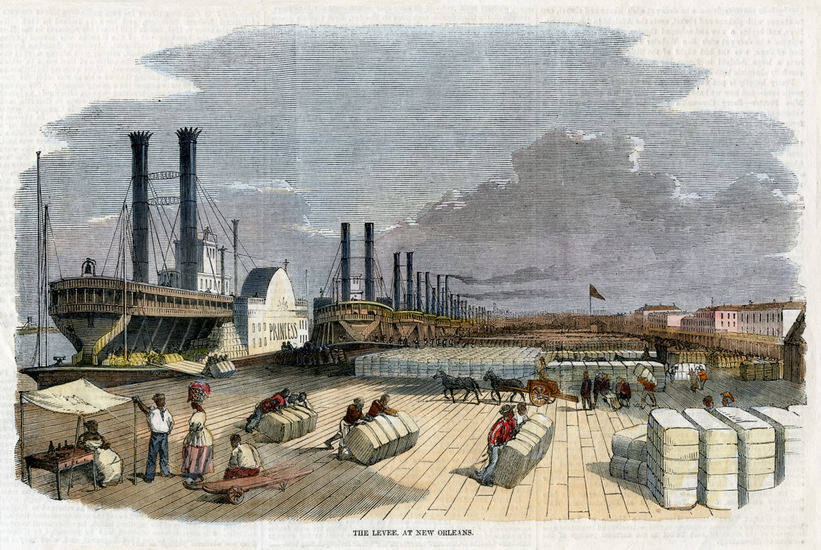
The engraving on this page in an 1858 edition of the Illustrated London News was hand colored by someone, probably in the 1970's.
ILLUSTRATED LONDON NEWS
June 5th, 1858
THE LEVEE AT NEW ORLEANS
NEW ORLEANS stands on the left bank of the Mississippi, about a hundred miles from its mouths, on a crescent-like bend of the river, whence its name of the "Crescent City."
By means of continual deposits of the vast quantities of mud and sand which it holds in solution, and brings down from the great wilderness of the Far West, the Mississippi has raised its bed to a considerable height above the level of the surrounding country, and is embanked for hundreds of miles by earthen mounds or dykes, of six or eight feet in height, called Levees. This name was originally given by the French, and is still retained by the dwellers on the banks of the Mississippi and Ohio. A Levee of this kind protects New Orleans.
The following description of the Levee at New Orleans is taken, from the letter of our Correspondent describing that city which appeared in the number of this Journal for the 10th ult.:
"The outdoor life of New Orleans is seen to greatest advantage on the Levee. The river can scarcely be seen for the crowd of steamboats and of shipping that stretch along the Levee for miles; and the Levee itself is covered with bales of cotton and other produce, which hundreds of negroes, singing at their work, with here and there an Irishman among them, are busily engaged in rolling from the steamers and depositing in the places set apart for each consignee. These places are distinguished one from the other by the little flags stuck upon them—flags of all colors and mixtures of colors and patterns ; and here the goods remain in the open air, unprotected, until it pleases the consignees to remove them. New Orleans would seem fit at first glance to overflow with wealth to such an extent as to have no room for storage. The street pavements actually do service for warehouses, and are cumbered with barrels of salt, corn, flour, pork, and molasses and bales of cotton, to such an extent as to impede the traffic, and justify the belief that the police must either be very numerous and efficient, or the population very honestly disposed. The docks of Liverpool are busy enough, but there is no bustle, no life, no animation, at Liverpool at all equal to those which may be seen at the Levee in the "Crescent City." The fine open space, the clear atmosphere, the joyousness and alacrity of the negroes, the countless throngs of people, the forests of funnels and masts, the plethora of cotton and corn, the roar of arriving and departing steamboats, and the deeper and more constant roar of the multitude, all combine to impress the imagination, with visions of wealth, power, and dominion, and to make the Levee as attractive to the philosopher as it must be to the merchant and man of business."
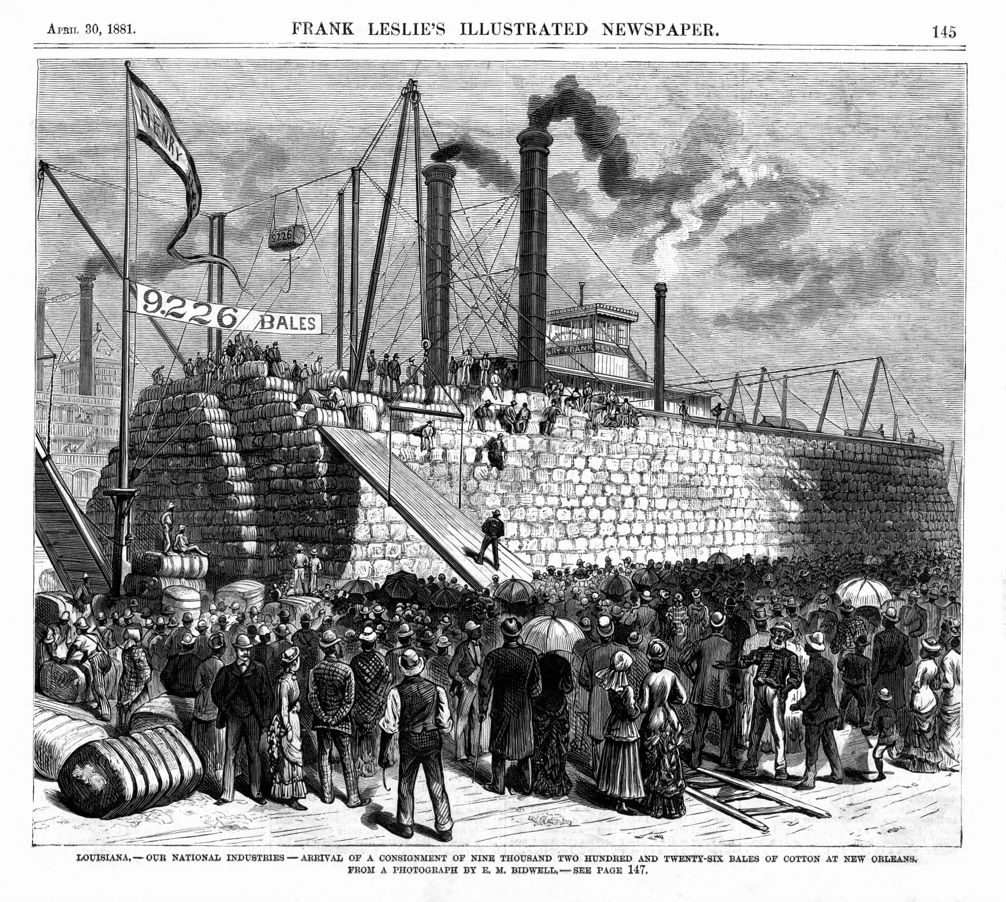
Frank Leslie's 1881 engraving of the cotton packet HENRY FRANK loaded with 9,226 bales of cotton
This iconic image of a fully loaded cotton packet is one I've been seeking for a long time. Luckily found the issue it came from with a dealer in Alabama last week. Great to have it in the collection at last.
We could make a "cotton packets" page, there are a great many images both in photographs and post cards as well as in engravings that depict these specialty steamers who were huge money makers for the Southern planters and the National economy.
FRANK LESLIE'S ILLUSTRATED NEWSPAPER
30 APRIL 1881
PAGE 145
LOUISIANA - ARRIVAL OF A CONSIGNMENT OF NINE THOUSAND TWO HUNDRED amp; TWENTY-SIX BALES OF COTTON AT NEW ORLEANS. FROM A PHOTOGRAPH BY E.M. BIDWELL.
Frank Leslie's Illustrated Newspaper—Text of article on page 147:
THE COTTON INDUSTRY AT NEW ORLEANS.
The largest cargo of cotton ever floated on the Mississippi was carried by the steamer HENRY FRANK from Natchez to New Orleans during the first week in April. The steamer belongs to the Memphis and New Orleans Packet Company, and is 285 feet long and 52 feet beam, with 12 foot hold and 2,600 tons burden. She has 6 boilers, each 28 feet long and 42 inches in diameter, the cylinders 29 inches in diameter with 9 feet stroke. Her immense wheel is 28 feet in diameter, 28 feet wide, and her buckets 28 inches. The steamer left Memphis, March 24th, with 2,596 bales of cotton, of which 2,093 were compressed, and 500 sacks of cotton-seed meal. At Scannel, Helena, the mouth of the White River, and several other points, she added largely to her cargo, so that when she left Natchez, April 1st, for New Orleans, she had on board 9,226 bales. The total cargo was thirteen tiers high, and was so stowed that the vessel not only moved with ease, but presented a most graceful appearance. Our sketch shows the steamer as she appeared after her arrival in New Orleans.
The amount of cotton carried this season into New Orleans by the Henry Frank to date, in her ten trips, is 68,515 bales, an average of 6,851 bales each trip.
For several years past the cotton merchants and factors in New Orleans have been demanding increased facilities for transacting business, not the least of which are suitable Exchange accommodations. If any special argument were needed beyond what has already been urged to establish the question of necessity, the arrival of the HENRY FRANK would have been sufficient.
About a year ago the site for a Cotton Exchange was purchased, and out of fifteen plans submitted on the last offer of premiums, the Building. Committee of the Exchange selected that of Mr. Wolters, a prominent architect of Louisville. The building he proposes is after the style of the French Renaissance, which succeeded the Gothic, and, though defective in some respects, is the most popular and appropriate style of street architecture in Paris. It is based on the antique, but is characterized by luxuriance and richness of ornament, pointed gables, mullioned windows, oriels and dormers, fantastic moldings and broken entablatures over the windows. The most striking peculiarity is the rococo ornament.
As designed by Mr. Wolters, the new Cotton Exchange will be four stories in height, with entresol and Mansard roof, which latter form is generally adopted in Paris, in connection with this style, since the days of the Mansards. The edifice has a front of about 72 feet, with a depth of 120. On the ground-floor will be the superintendent's office, " future" room, and the Exchange proper—a hall, 110 feet long, 50 feet wide and 30 feet high, with a gallery for visitors.
The upper floors are intended for offices. The extreme height of the building will be about 80 feet, and the façade of the Carondelet Street front, as shown by the architect's sketch, is elegant and very imposing. It displays several of the peculiar features of the Renaissance style; caryatides supporting the entablature of the entrance-door, mullioned windows, broken gables, pilasters with classic capitals, balconies, ornate moldings, and a dormer in the Mansard roof. The gable surmounting the entrance is crowned with two cotton bales, and at the apex of the uppermost gable of the façade are the coat-of-arms of Louisiana and the device from the great seal of New Orleans.
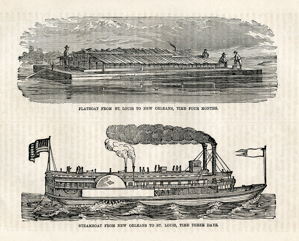
Two engravings on page 182 which had been extracted by a dealer from a copy of the following 145 year old book:
EIGHTY YEARS PROGRESS OF THE UNITED STATES
A FAMILY RECORD OF AMERICAN INDUSTRY, ENERGY AND ENTERPRISE
HARTFORD, CONN.: PUBLISHED BY L. STEBBINS. 1869.
The engravings appear to have been created during the 1840's: a flatboat's time consuming transport of goods by 4 months on the Mississippi between St. Louis and New Orleans
is compared to the speedy transport by steamboat by 3 days from New Orleans to St. Louis.
By incorporating the last paragraph that I found elsewhere from page 180 in the book I added it to the text on page 181 and came up with the following which I have abridged:
"The settlers who had crossed the mountains in the early times . . . had located mostly on the great streams, within easy reach of the means of conveying (their) surplus to points of sale.
They were not provided with vessels of a very expensive construction; and flat boats were the chief means of descending the streams.
These vessels, designed only to go down stream, were composed of such material as, after having served the purpose of transporting produce, could be broken up at the place of destination, and sold as lumber . . .
It required four months to travel thus from New Orleans to St. Louisa distance of 1,500 miles, and the cost of the goods, it may well be supposed, was enhanced by the process; while, on the other hand, the produce sent down realized but little.
Thus, between the cheapness of the produce and the dearness of merchandise received in exchange, time settler realized but little for his labor.
It is easy to conceive how great a blessing was steam on those waters, to enable the weary men to stem the ceaseless, downward flow of the mighty currents.
In 1811 that blessing made its appearance at Pittsburg in the shape of a steamboat, built by Fulton, and which had a considerable success.
The general progress was, however, slow, for the reason, among others, that, as in all such cases, there was a large capital invested in river craft, which would depreciate in value in face of the new power, and there was not much capital to embark all at once in steam.
It was also the case that Chancellor Livingston, the partner of Fulton, claimed a monopoly of the lower Mississippi trade, and put a restraint for some years upon steam in that region. So great a power could not, however, but force its way.
With the construction of the ENTERPRISE, in 1815, St. Louis was reached in 25 days from New Orleans, and public enthusiasm was aroused.
There were, however, up to 1817, still but twelve boats upon the western waters, of an aggregate tonnage of 2,335 tons.
The time to Pittsburg was 54 days, of which 36 days was running tune.
These passages caused much excitement, and a bold merchant predicted that the rate of freight between New Orleans and St. Louis would fall to $3.50 per 100 lbs., but lie was regarded as visionary, or what they would now call in Wall-street language a "bear" in freights.
His sanguine nature would probably have been surprised could the veil of time have been so lifted as to permit him to see 35 years ahead—the boats of the present day making money at 40 cents per 100 lbs., and carrying it in three days . . ."
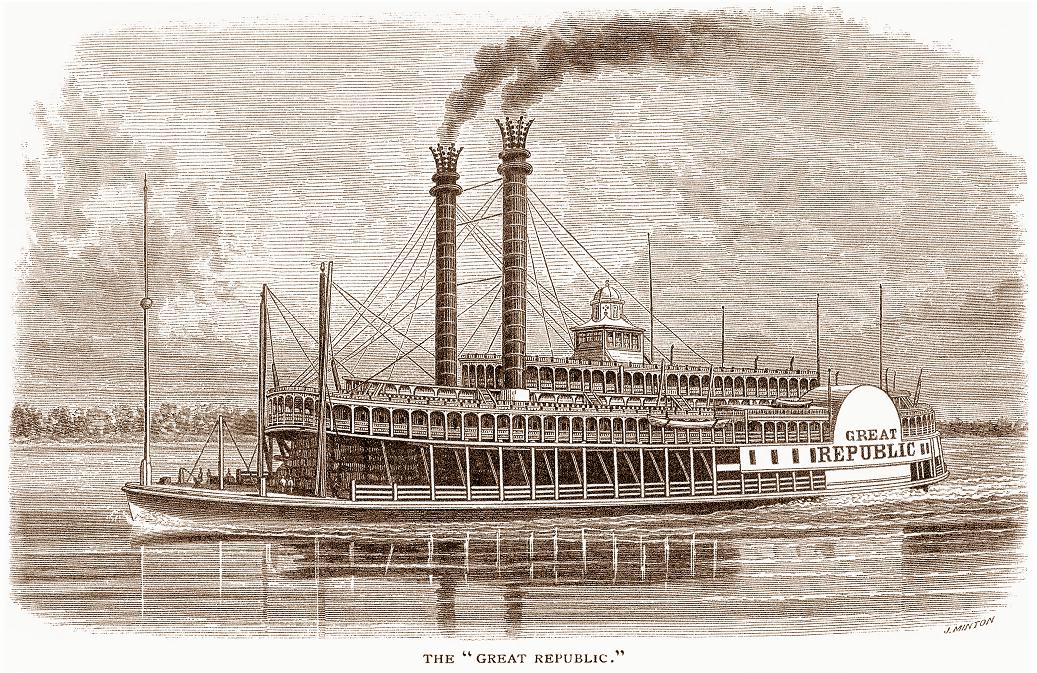
Scribner's Monthly October 1874 . . . Great Republic Portside 3/4 portrait engraving.
Detail of the vignette on an 1850 waybill written by Henry M. Childs, a forwarding and commission merchant at Catlettsburg, Kentucky which is at the confluence of the Ohio and Big Sandy River in 1850.
The name of the boat is written in long hand and the only word it vaguely resembles is "Nebraska." I sent you a scan of the document itself and perhaps you or someone in our "fan base" will be able to decipher it.
There must be folks who specialize in reading the scrawls of the penmanship-challenged folks of yesteryear.
brief history excerpted from Wikipedia: Wikipedia
Catlettsburg is located in the northeast corner of Kentucky at the confluence of the Ohio and Big Sandy rivers. It is considered part of the Kentucky, West Virginia, and Ohio "Tri-state area".
A United States Post Office was first opened here in 1808 as Mouth of Sandy, Va.
In 1849, civil engineer James Fry, was commissioned to lay out the original town of Catlettsburg (the area from 24th to 26th streets, and from the former Front to present-day Walnut Streets). T
The lots were quickly sold, and the community was named after brothers Horatio and Alexander "Sawny" Catlett.
They first settled here in in 1811 and resided at the location for at least 26 years.
After establishing this settlement, the Catlett's operated a combination business here that consisted of a tavern, post office, trading post, and inn, all out of a log structure they built from virgin timber in 1811.
Due to its location along the route of the American frontier, the Catlett's provided hospitality to such notable patrons as General Stonewall Jackson, Henry Clay, Felix Grundy and future U.S. President James Garfield.
Catering to the ever growing river traffic, the Catlett business flourished and the present day town grew up around it. Unbelievably, the Catlett home built in 1811 is still standing two hundred years later, and has long been used as the "servants quarters" of Beechmoor Place, a large home located on Walnut Street.
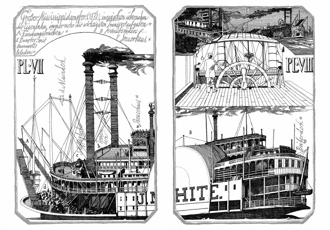
Klaus Ensikat's "double plate" steamboat illustration for a German translation of Mark Twain's HUCK FINN
Huckleberry Finns Abenteuer by Mark Twain
Published by Neues Leben - Berlin, 1979.
Klaus Ensikat created 65 full page illustrations and vignettes for this edition.
Ensikat's choice to "torque" the J.M. WHITE is interesting. He's use (make that used) two perspectives: a high angle on the left (Plate 7) and a low angle on the right (Plate 8) Amazing technique and historically accurate, lots of research went into this. He included the names of parts of the boat in gray "handwriting" style lettering. Klaus derived his pilot house interior from an engraving in Scribner's Monthly from October 1872. It represented the pilot house of the GREAT REPUBLIC. Klaus switched the pilot from the right side of the wheel to the left in his version.
Ensikat also illustrated Mark Twain's TOM SAWYER and LIFE ON THE MISSISSIPPI.
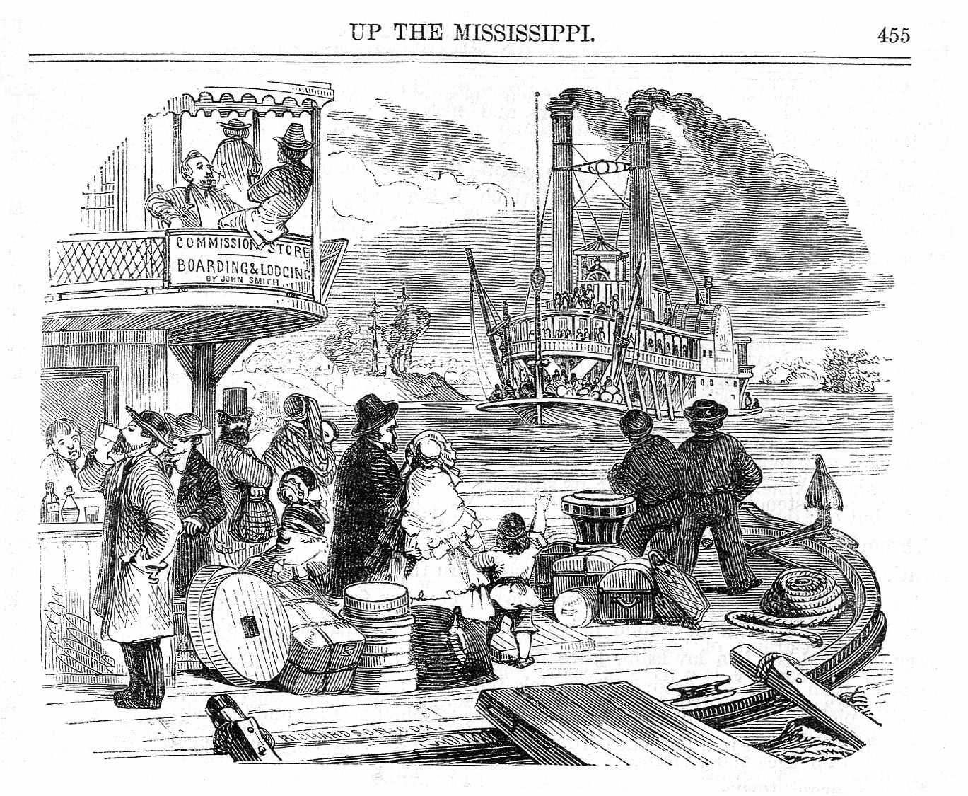
Attached scan of the illustration on page 455 from a leather bound issue of the Emerson's Magazine / Putnam's Monthly Volume 10 for 1857.
The October 1857 issue contained UP THE MISSISSIPPI. The author of the article is not mentioned but the illustrator was Jacob A. Dallas. The last of the 21 illustrations by Dallas was the best, being this view from a wharf boat with passengers awaiting the approach of an oncoming packet. The bar on the outside of the wharf boat is interesting. Probably made it easier for thirsty gents to keep an eye on the river when they were on deck so they wouldn't miss the boat which might happen if they were absorbed with drinking at a bar on the inside of the wharf boat. The two thick bodied characters on the right, standing between the capstan and the anchor look like they were either deep ocean sailors on leave and touring the Mississippi River or deck hands who would assist the steamboat's crew when they tied up at the wharf boat to load and unload passengers and freight.
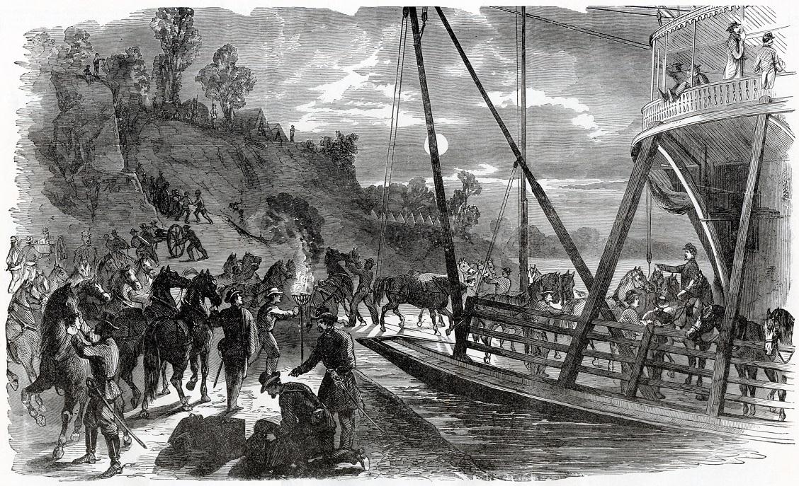
EMBARKING TROOPS AT BIRD'S POINT, MISSOURI., TO REINFORCE THE FEDERAL ARMY UNDER GENERAL PRENTISS. - From a Sketch by Henri Lovie
General B. M. Prentiss assumed command of the Northern District of Missouri in September,1861 , and immediately established a line of camps along the Hannibal and Missouri River Railroad.
No organized force of Confederates existed north of the Missouri River at that time but numerous bands of partisans raided the country seizing the property of loyal citizens and obstructing the movements of the Union Army.
A large force of troops joined Prentiss during the fall, and several important actions were fought by him, all ending in the defeat of the guerrillas.
Many of the soldiers of the department accompanied General Prentiss to the field of Shiloh, where his division displayed unusual gallantry in resisting the assaults of superior numbers.
From THE CIVIL WAR IN THE UNITED STATES page 82 1896
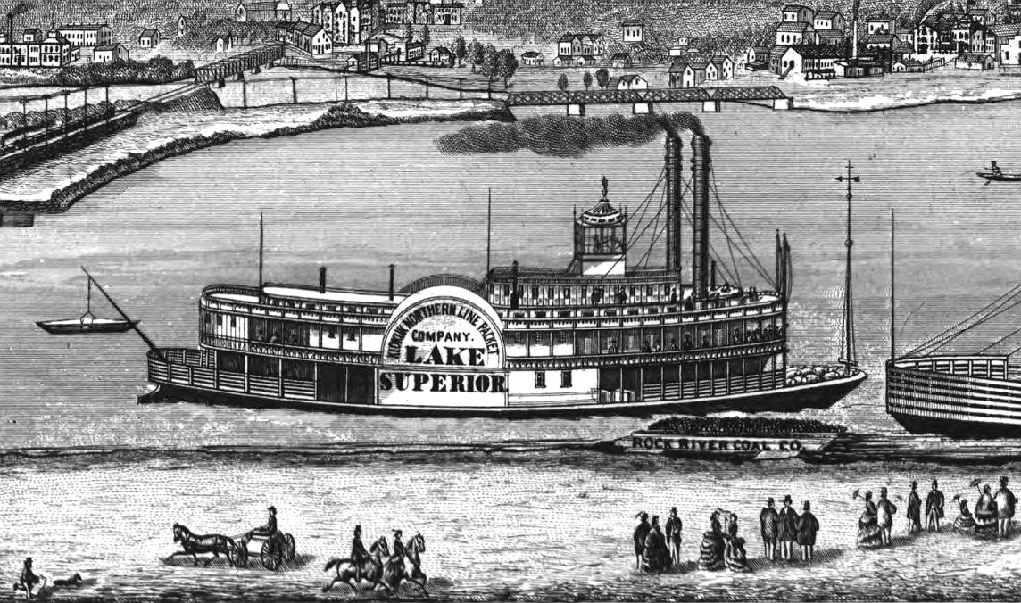
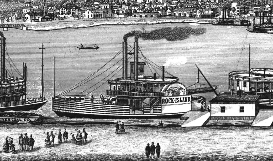
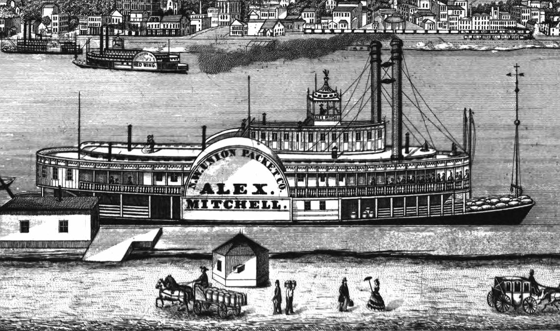
Panorama of Rock Island, Illinois, as seen from Davenport, Iowa.
The artist August Hageboeck drew 4 steamers in the foreground with wonderful precision.
Published Davenport, Iowa 1874.
Library of Congress collection.
The steamboats in the long, narrow panorama are from left to right
LAKE SUPERIOR, the ferry ROCK ISLAND, ALEX MITCHELL and CLINTON.
LAKE SUPERIOR
1870-1879
Sidewheel Packet
Way's Packet Directory Number 3355
Built in 1870 at Wheeling, West Virginia (hull) and completed at Pittsburgh, PA
Her engines came from the HAWKEYE STATE. The original construction and design was supervised by Richard C. Gray. She was the 14th boat built in the area for the Northern Line Packet Company. Her machinery was built by Robert Lea; Dunlevy and Company built the hull. Emil Bott did the landscape painting in the cabin. She ran St. Louis-Keokuk-St. Paul. She was the first boat of the season to arrive at St. Louis from below on April 10, 1875. In June 1876, she brought 800 tons of silver ore from St. Paul to St. Louis consigned to the St. Louis Smelting Company. The fire that destroyed both the LAKE SUPERIOR and the DUBUQUE in Alton Slough on March 4, 1879 was thought to have started in the barbershop of the LAKE SUPERIOR. Both boats were being readied for the season at the time.
ROCK ISLAND
Sidewheel Ferry
Way's Packet Directory Number 4810
Built 1875 at Clinton, Iowa. Around 1909, the T.J. ROBINSON was renamed ROCK ISLAND. She operated between Davenport and Rock Island teamed up with the Davenport. She later worked as the ferry at Helena, Arkansas. After she was beached out and dismantled around 1922, her machinery went to the CAROLYN.
ALEX MITCHELL 1870-1881
Sidewheel Packet
Way's Packet Directory Number 0123
Hull built in Paducah, Kentucky and completed in La Crosse, Wisconsin with four boilers in 1870. Owners were N.W. Union Line (1870-1872); Keokuk Northern Line (1872-1880); St. Louis and St. Paul Line (1881).
Arrived at Pittsburgh March 12, 1871 with a cargo of iron ore and then loaded out direct for St. Paul; named for the president of the Milwaukee and St. Paul railroad with which her owners had prorating arrangements at Prairie du Chien and at La Crosse; reported to have run New Orleans to Shreveport on several occasions; froze in ice at La Crosse on way to St. Louis; wrecked by tornado at Wells Landing in 1876 while James H. Hauser was clerk; after dismantling in La Crosse, Wisconsin 1881, the cabin and machinery went to the second GEM CITY.
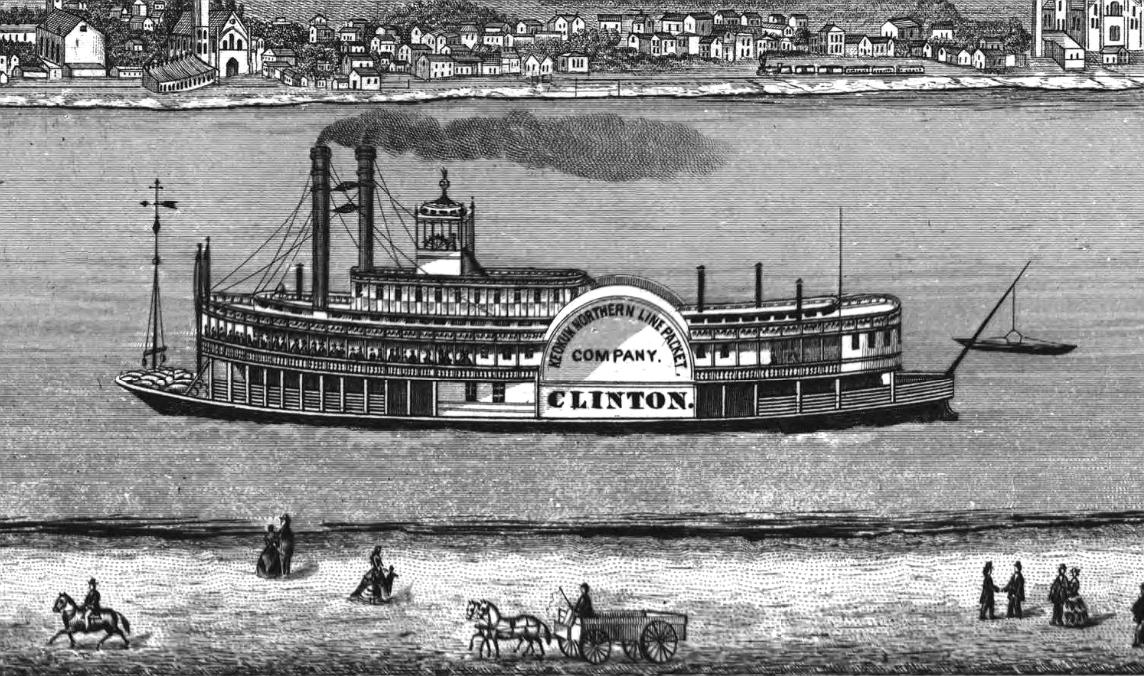
CLINTON (1872-1884)
Sidewheel Packet
Way's Packet Directory Number 1191
St. Louis, Missouri, 1872 and owned by Keokuk Northern Line Packet Company; Merchants' and Planters Packet Company She ran the Upper Mississippi trades while in the Keokuk Northern Line Packet Company. Captain John N. Shunk had his last command on the St. Louis-Cincinnati run. In 1884 she was running New Orleans-Bayou Sara under the Merchants' and Planters Packet Company

With the exception of images credited to public institutions,
everything on this page is from a private collection.
Please contact Steamboats.com for permission for commercial use.*
All captions provided by Dave Thomson, Steamboats.com primary contributor and historian.